|
|
| |
About CulvertBC ...
The overall aim of CulvertBC is to develop a set of procedures, criteria, and
standards to define the technology of hydrologic/hydraulic design
for forest road stream crossings in BC, and to make
these available to practising professionals and technicians. This
involves a review of methods and techniques presently being used,
carefully selected research studies, wide consultation with
practitioners, selection of the most suitable methods for design,
and updating or, where appropriate, developing new methods, for:
- estimating the flow to be used for design in a particular
situation
- developing a set of "best practices" for making
design decisions on bridges and culverts, in different
circumstances
- developing a set of best practices for ongoing
maintenance and repair of culverts and bridges
Site overview ...
- home: this page.
- classroom: notes on basic hydraulics; all you want to know about Q100
NEW in CLASSROOM section ...
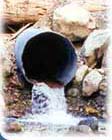
- Images of typical forestry creek crossing structures
- Estimating peak floods for the design of culverts and bridges for forest roads
- River systems
|
- tools: useful tools for various hydrologic calculations.
NEW in TOOLS section ...
- Interactive map of BC with Multiplier Information for each Hydrologic Zone - just click your area of interest on the map.
- Forest Road Deactivation Practices in the Pacific Northwest - online InfoFlip "flipchart" meant to assist machine operators and supervisors in the task of completing deactivation of forest roads.
- Estimating Design Floods for Forest Roads in British Columbia - an overview of current standard methods, recommendations for measuring peak flows, a summary of steps in estimating Q100 with example.
- Forest Road Drainage Installation Practices in the Pacific Northwest - online InfoFlip "flipchart" meant to assist in the selection of appropriate sites and types of drainage structures, and guide construction during structure installations.
|
- case studies: (under construction) applying procedures, criteria and standards from this project in real world examples
- publications: papers which have been published on this topic to date
- links: sites related to forest hydrology; submit your own link to our list
- BC map data: data from BC hydrological stations operated by the Water Survey of Canada
- feedback: contact information for the people behind CulvertBC
The research is presently
undertaken by the Department of Civil Engineering at the University of British Columbia. Funding for this project has been generously provided
by Forest Renewal British Columbia (FRBC)
|
|
|