Introduction:
The first step in designing a culvert or bridge for a particular location is to determine the design
flood 1. This is the flood that the culvert or bridge must be able to carry safely. This involves first
choosing the return period for the design flood, which involves considerations of cost, risk,
consequences of failure, how to deal with uncertainty 2 and so on. However, the BC Forest
Practices Code makes it relatively simple by specifying Q100 3 (the 100 year flood) as the design
flow. A permanent bridge must be able to pass Q100, with adequate freeboard and a culvert must
be able to pass it, with the water level water no higher than the top of the entrance to the culvert.
Q100 is the flow that, on average, is exceeded once in 100 years. This is a very conservative
requirement, which means that, the estimated design flow already has a fair margin of safety built
in to it.
There are several standard ways of estimating Q100, depending on the area and the type of data
available. But they have to be based on data either rainfall data or stream flow data. There is
no theory on how large a flood can be only theories on how to estimate design floods from the
available data. There are rainfall intensity gauges and stream flow gauges throughout British
Columbia, but they are few and far between and almost all are located in the valley bottoms. In
relatively flat, inhabited areas, such as in cities and suburbs, where design floods are needed at
many places for the design of storm drainage systems, it is much easier and cheaper to install
rain gauges than stream flow gauges. Hence, in such areas, design flows are usually estimated
from rainfall intensity data, using standard methods 4. This however, is not the case with forest
road crossings in BC. If good streamflow data exists, there are statistical ways 5 to estimate
design floods from flow data. These are effective on the stream where the measurements were
taken or close to it. However, considering the wide spacing of the gauges, the range in elevation
and the variability in topography and climate, across the province, it is easy to see that
conventional ways of estimating design floods are unlikely to provide satisfactory estimates.
To estimate design floods in an area for, say a new, forest road, we recommend that a regional
approach, be used for estimating Q100, using the formula Q100 = KA 0.8 . A is the watershed area of
the stream at the location of the proposed crossing and the exponent 6 of 0.8 (the power to which
A, the watershed area is raised) is rounded from the value of 0.785 derived by the Hydrology
Division of the BC Ministry of Environment. We recommend that values of K be derived for each
specific region, on the basis of average peak flows in the region and regional peak flow data from
the Water Survey of Canada. We recommend that estimates of the average peak flow be based
on actual measurements of peak flows, in the area and on the ratio of the long-term average peak
flows in the region to the peaks in the year the measurements are taken. These ratios can be
derived from Water Survey of Canada data at key index stations - and they will be posted on this
web site. Multipliers giving the ratio of Q100 to Q2 (the long-term average peak) will also be posted
on the web site for the various hydrologic zones in the province. These will be estimated from
Water Survey of Canada data, assuming a Gumbel distribution of the flood peaks. Peak flows
can be estimated from peak water levels, which can be measured readily with peak water level
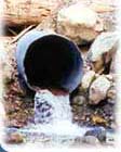
gauges (see suggested design) and a knowledge of the channel geometry. The best location for
a peak water level gauge is just upstream of an existing culvert. If the culvert has a slope greater
than 1% and the water does not back up from the downstream end, the culvert is said to have
entrance control. In this case the flow corresponding to any particular water level can be
computed with reasonable accuracy, from the culvert diameter and the water level relative to the
bottom of the culvert. The web site provides for such calculations. If there is not a culvert, the
calculations are a little more complex as it is necessary to measure the channel geometry as well
and the peak water level. But again, the calculation is straightforward and the web site can still
accomplish this task.
1. The Design Flood
The design flood for a structure, such as a bridge or culvert, is the flow that the structure must be designed to pass safely. It is specific to the location of the proposed structure and it is usually specified by its "return period". For example, the 10 year flood on the Fraser River at Hope, BC, has a magnitude of 11,000 m3/s (cubic metres per second). This is an extreme example, but one with recognizable names. It illustrates that the stream must be specified - in this case the Fraser River; and the location of interest must be specified, in this case Hope (and if one wanted to be accurate, the highway bridge over the Fraser just upstream of Hope, where the stream gauge is located). Also, the return period must be specified, in this case 10 years. Typically one might use the 10 year return period flood in designing a facility such as a riverside park, where the consequence of flooding would not be too serious. In this example, 10 years is the average length of time between successive flows (in the Fraser River at Hope) equal to or greater than 11,000 m3/s, the design flood. Often, the 10 year return period flood is simply called the 10 year flood or Q10.
[ ^ return to Introduction ]
2. Dealing with Uncertainty in Design
Engineers use one or more of three basic approaches to handling uncertainty in design:
- "Bounding", when failure would be unacceptable. Taking a bridge structures as an example, there may be uncertainty about the load, but there must be some upper limit - L on the load, that we can be quite sure cannot be exceeded. And, while there may be uncertainty about its carrying capacity, there must be some load - C, that we can be quite sure that it can carry. Then if C is greater than L, we can be sure that the bridge will be safe. And, if we get anxious, we can add an extra safety margin.
- Choose a design that minimizes the "total expected cost", in situations where failure would not be unacceptable. Expected cost is a technical term that includes the consequences of failure and the probability of failure. Often an acceptable probability of failure is specified - as in the case f forest road culverts in BC, which have to be designed for Q100, the 100 year peak flood - the flood that has a 1% chance of occurring in any given year.
- Control the uncertainty with design features. For example, in bridge design, concern about differential settlement of the foundations, can be eliminated by providing simply supported spans.
The structural design of bridges comes under Category 1 above, while the hydraulic design of bridges and culverts comes under Category 2. To see the difference, imagine how you would feel if you were the structural designer of a bridge deck that collapsed under the weight of a logging truck. Compare this with to how you would feel if you had estimated Q100 for a bridge and then it got swept away in an unusually large flood.
Other useful rules
- A useful rule of thumb for uncertain situations, it that if one gets roughly the same answer with different methods, one can feel more confident that the answer is right. But, if they do not agree within reasonable limits, then one has to chase down why they do not and which is more likely to be right.
- When key figures or dimensions are given in round numbers they are more likely to be accepted by other professionals, than if they are "non-round" numbers. Imagine trying to get a group to accept as the design flood the 77.3 year return flood.
[ ^ return to Introduction ]
3. Q100
Q100, the 100 year return period flood, was chosen as the design flow for culverts and permanent bridges under forest roads, in B.C., by a committee. It is very conservative. For example, California State Highways use Q100 for the design of culverts under their major highways, but size the culverts, by assuming that the water level can come up to the highway level, not just to the top of the culvert, as in BC. In theory, the design flood return period should be selected to minimize total expected cost, that is the cost of the structure in the first place plus the expected cost of repair or replacement, in the event of damage or failure. However, this is too complicated for most practical situations and a simple rule of thumb is usually used. For example, storm drainage conduits and structures in urban areas are typically designed for no damage under the 10 or the 25 year flood and no unacceptable damage under the 100 or 200 year flood. This requirement makes designers think not only about "ordinary" floods but also about what could happen under a really large flood. For example, should a really large storm flow exceed the capacity of a culvert under the Upper Levels Highway in West Vancouver and overtop the highway, the results could be catastrophic. In contrast, on a secondary road in a flat sparsely populated area, the consequences of overtopping the highway might be minimal. For culverts and bridges under forest roads similar criteria - sizing for the 25 year flood, but checking that no unacceptable damage would occur under he 100 year flood, would probably make more sense that the present rule. Perhaps, the rules may be changed some day, but in the meantime, culverts and bridges, for forest roads, have to be designed for Q100.
Designers should also consider what would happen if there were a flood large enough to cause the bridge or culvert to fail. This could be a flood larger than Q100 or it could be a smaller one with a heavy debris load. In addition to the code requirement of being able to carry Q100, the consequences of failure should also be examined. If these are judged to be unacceptable, the design should be modified to minimize the adverse consequences of failure. For example if a road crosses an alluvial fan, the crossing should be at the low point in the road, so that in the event of overtopping, the flow would still stay in the stream bed rather than break out of its bed. In practice, culverts and bridges should be designed for "safe fail", that is for minimal damage to the road, the stream and the environment in the event of failure. It is worth noting that Q100 already contains a large factor of safety, so additional factors of safety are not needed on the design flows.
[ ^ return to Introduction ]
4. Methods of Flood Estimation based on Rainfall Data
One of the earliest and best known techniques for estimating peak flows is the rational method. It was developed mainly for estimating urban drainage flows for storm sewer design and it generally produces reliable results for small watersheds where the input parameters can be properly quantified. The equation is Q = CIA/360, where Q is the design flow in m3/s. C is a co-efficient that estimates the fraction of rainfall that runs off (the rest is assumed to sink into the ground and not appear in the stream until after the peak flow has passed). I is the average rainfall intensity during the time of concentration, Tc, the time that it takes water to flow from the highest point in the watershed to the point of interest. Tc is also knows as the "response time" of the basin, and A is the watershed area in hectares. Other estimating techniques used in BC are the Burkli-Zeigler equation and the Talbot formula, both essentially modifications of the rational formula. These both use a runoff co-efficient and Tc, the "time of concentration".
Another more sophisticated method of estimating flood flows on the basis of rainfall data, it to use a rainfall-runoff model. There are many "models" available and all attempt to simulate the key features of the rainfall-runoff process. However, the actual process is extremely complex and almost impossible to model accurately. Computer models are now available that require little more input than the rational method. At present, they are used mainly for large streams, which have bridge crossings, rather than culverts.
Practical difficulties arise with all the methods for estimating design floods on the basis of rainfall data. It is difficult to estimate Tc, the time of concentration, C, the fraction of the rainfall that runs off (rather than sinking into the ground) and I, the "design" rainfall intensity. Depending on their complexity, rainfall-runoff computer models can have additional data demands that can be difficult to satisfy. For urban areas, which are generally reasonably flat, it is possible to develop ways of estimating these parameters and gradually "fine tune" them, with measured data. For forested watersheds in a mountainous province like British Columbia, it is just not realistic to expect other than extremely erratic results from any of the flood estimating methods that rely on rainfall data. However, it is worth noting, that an experienced hydrologist working in an area, and using a technique, with both of which s/he is thoroughly familiar, can probably obtain reasonable results, with any particular method. In this case, the hydrologist's experience is much more important than the method s/he uses.
[ ^ return to Introduction ]
5. Statistical methods for flood estimation.
Where there are good peak flood statistics on a creek or river, floods with a particular return period can be estimated by statistical methods. There are textbooks that explain the methods in detail. Before the advent of computers, the standard way to analyze flood data was to first list the magnitudes of the annual peak floods (the biggest flow in each of the years of record) and compute the "return period" for each, from the formula Rp = (n+1)/r. Rp was the return period in years, n the number of years of record and r the rank of the flood - 1 for the largest, 2 for the next largest and so on. Then the flood magnitudes were plotted against the corresponding return period and a curve was drawn through them. Flood peaks with any particular return period could then be read off the curve. However, there was a problem with return periods longer than the length of the record. The curve had to be extrapolated and it is almost impossible to extrapolate a curve with any confidence, unless it happens to be a straight line. Early statistical flood hydrology largely involved a search for plotting paper that would result in such straight line plots. Nowadays, with the availability of computers, data can be fitted to theoretical distributions. Since there is now an underlying equation, the relationship between flood magnitude and return period can be extrapolated by computer to give the flood with any desired return period. Oddly, most hydrologists are comfortable with this, although they would have been very uncomfortable extrapolating curves by hand.
There are several standard statistical distributions that are widely used. There is some logic to the Gumbel distribution in that, if one were to analyze the distribution of the largest value in each of a number of samples of the same size, from a population with an underlying normal distribution, the result would be a Gumbel distribution. An example could be the heights of the tallest boys in each Grade 10 class, in a school district, if all the Grade 10 classes had the same numbers of boys. Note that if we included all the students, we would be mixing two "populations" - girls and boys, who have different height characteristics.
It has been argued that since the factors that influence a flood flow tend to multiply the effects of one on another, the resulting distribution should be lognormal (Ven Te Chow, 1955). Thus there is also some logic to the use of the lognormal distribution. Both the Gumbel (also known as the Extreme Value Type I distribution) and the lognormal distributions are "2 parameter" distributions in that they can be specified by the mean and the standard distribution. The other widely used distribution is the Log Pearson Type III distribution. This was chosen for use by U.S. agencies for political reasons - as a "neutral" distribution, when all U.S. agencies were forced to agree on the use of one distribution. It is a 3 parameter distribution, specified by the mean, standard deviation and the co-efficient of skew. It is more flexible that the other two, but estimating the co-efficient of skew poses problems and it is doubtful if it provides any greater accuracy than the Gumbel and the lognormal distributions.
To properly use a statistical distribution, the data should meet certain conditions, such as having no underlying trend, no cycles and so on. In practice, these conditions are rarely met. After the last El Nino weather cycle, everyone now knows that there are cycles in climate and hence in flood peaks, although the cycles are irregular and almost impossible to predict. Also flood peaks on a particular stream often come from different statistical "populations". For example, some floods may be due to rainfall, some to snowmelt and some to a mixture. And on the foothills of the Rocky mountains, some very large floods result from storms which back up from the Gulf of Mexico, while the "ordinary" floods result from storms that come over the Rockies from the West. Given the general "impurity" of flood data and the fact that the conditions for strict application of statistical methods are almost never met, it seems sensible to just use a simple distribution and accept the fact that there could be errors in the computed design floods. From a management point of view, consistency in approach and methodology, along with reasonable accuracy is probably more important than striving for great accuracy in individual cases.
We recommend that the Gumbel distribution be used. It is the simplest distribution to use and, as outlined above there is some logic to its use. To use the Gumbel distribution, to estimate a particular flood, such as Q100 at a particular location, it is necessary to first estimate the long-term average flood at that location and its co-efficient of variation. The co-efficient of variation is the standard deviation divided by the mean and it is quite a stable statistic. While the co-efficient of variation does not vary much over wide areas, the average peak flood per unit area varies considerably with the location and the drainage area. The drainage area, or as it is often called the "watershed" area, is the area that the creek drains. For similar areas, the flood peaks seem to vary with the drainage area raised to the power 0.8 (this figure of 0.8 was derived by and is used by the BC Ministry of Environment, Lands and Parks).
[ ^ return to Introduction ]
6. The exponent to use for regional flood estimates
For estimating design floods, such as Q100, it is best to use a regional estimating technique, using a formula of the form Q100 = KAn , where K is a constant for the region we are in and A is the watershed area (also called the drainage area) of the creek at the location, for which we are trying to estimate the design flow. Unfortunately, "n" varies with the location, with the range of area, we are interested in and with the return period of the flood.
For practical purposes, we are more interested in using a simple method that gives reasonable, consistent answers than a more complex approach, that might give more accurate answers, but requires a more information than is usually available and may need more effort than we are prepared to make. We have found that for relatively small watersheds, of a size, where culverts are usually needed, the peak flows, seem to vary with the watershed area raised to the power of 1.0 or slightly less. However, there is a general expectation that "n" should be less than 1.0 and the Ministry of Environment have been using a value of 0.785 for the exponent "n". In contrast the forestry publication XXX, suggests an exponent of 0.60. We recommend a value of 0.8 as a rounded value of the 0.785 used for years by the Ministry and, for consistency, we recommend that this value be used throughout the province. The formula for estimating Q100 thus becomes Q100 = K A0.8. A is watershed area, that can usually be estimated by planimetering from a map (or the latest digital alternative). Then, all that is needed is to estimate K for the particular region of interest.
References:
Chow, Ven Te (1964). Handbook of applied hydrology: a compendium of water-resources technology. New York, McGraw-Hill.
[ ^ top of page ]